Jersey War Tunnels - geograph.ci - 350.jpg
From Underfoot Expounder
File:Jersey War Tunnels - geograph.ci - 350.jpg
Jersey_War_Tunnels_-_geograph.ci_-_350.jpg (640 × 404 pixels, file size: 294 KB, MIME type: image/jpeg)
| Description |
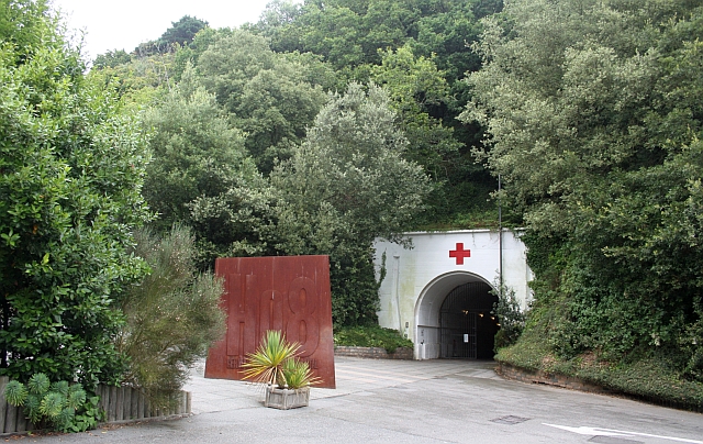
Jersey War Tunnels. The German Underground Hospital, H?angsanlage 8, was built between 1941 and 1944 by using forced labour from countries throughout conquered Europe. |
| Date | |
| Source | From channel-islands.geographs.org; transferred by User:oxyman using geograph_org2commons. |
| Author | Bob Embleton |
| Permission (Reusing this file) |
Creative Commons Attribution Share-alike license 2.0 |
| Camera location | | View this and other nearby images on: OpenStreetMap |
|---|

|
This image was taken from the Geograph Channel Islands collection. See this photograph's page on the Geograph website for the photographer's contact details. The copyright on this image is owned by Bob Embleton and is licensed for reuse under the Creative Commons Attribution-ShareAlike 2.0 license.
|
- You are free:
- to share – to copy, distribute and transmit the work
- to remix – to adapt the work
- Under the following conditions:
- attribution – You must give appropriate credit, provide a link to the licence, and indicate if changes were made. You may do so in any reasonable manner, but not in any way that suggests the licensor endorses you or your use.
- share alike – If you remix, transform, or build upon the material, you must distribute your contributions under the same or compatible licence as the original.
File history
Click on a date/time to view the file as it appeared at that time.
| Date/Time | Thumbnail | Dimensions | User | Comment | |
|---|---|---|---|---|---|
| current | 17:00, 23 May 2010 | | 640 × 404 (294 KB) | wikimediacommons>File Upload Bot (Magnus Manske) | {{Information |Description=Jersey War Tunnels. The German Underground Hospital, H?angsanlage 8, was built between 1941 and 1944 by using forced labour from countries throughout conquered Europe. <br /> Its construction involved the removal of 43,900 tonne |
File usage
The following page uses this file: